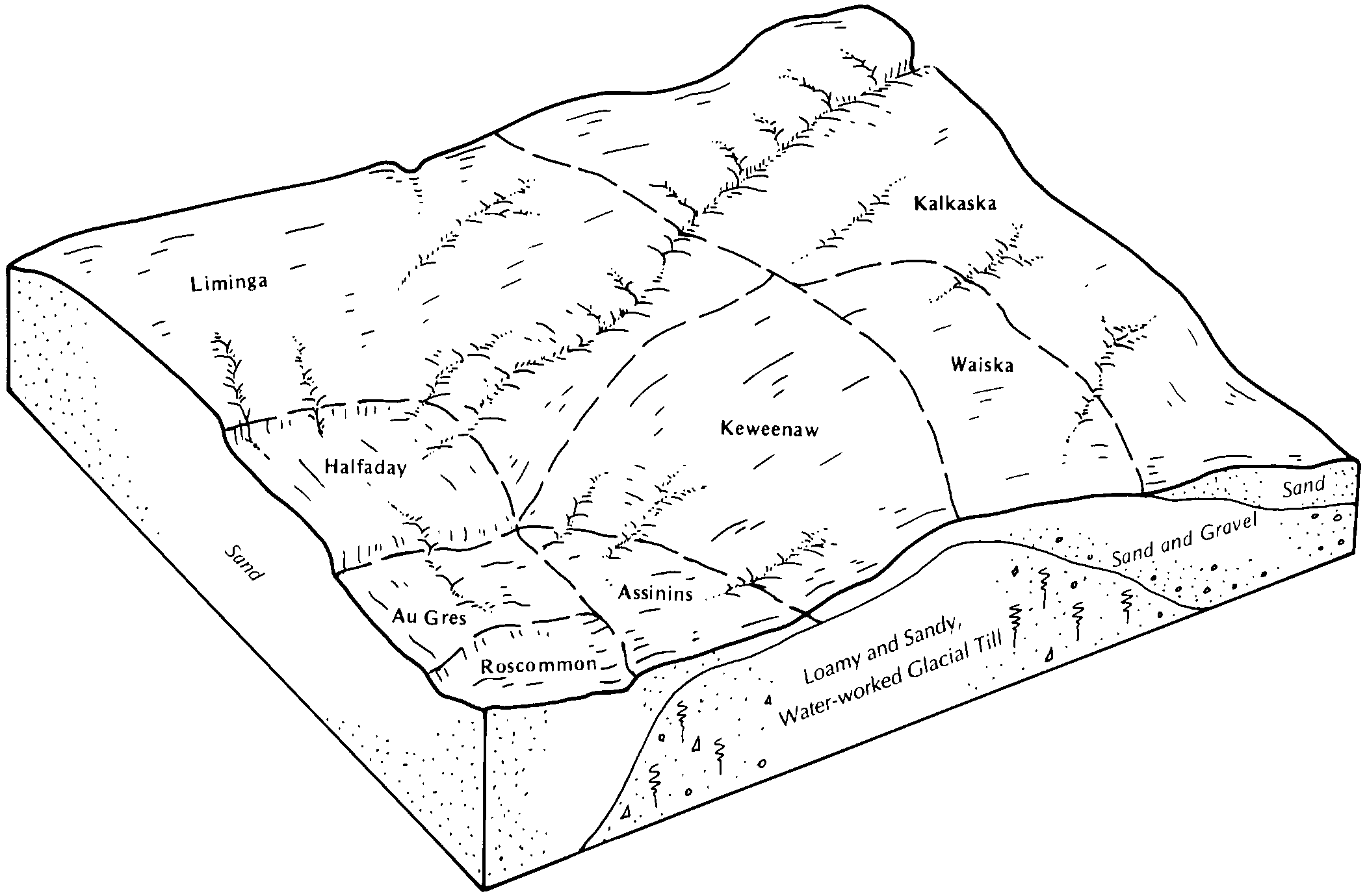
| Au Gres loamy sand | Au | 5597 | 315665 | blgr | me005 | 1969 | 1:24000 |
Tawas-Au Gres complex, 0 to 4 percent slopes | 12B | 6031 | 190243 | 6cyw | mi001 | 1993 | 1:20000 |
Au Gres sand, 0 to 3 percent slopes | 18A | 5534 | 190249 | 6cz2 | mi001 | 1993 | 1:20000 |
Au Gres-Allendale-Croswell sands, nearly level | 253A | 1926 | 190296 | 6d0l | mi001 | 1993 | 1:20000 |
Au Gres sand, nearly level | 262A | 1395 | 190297 | 6d0m | mi001 | 1993 | 1:20000 |
Haplosaprists, euic-Au Gres complex, nearly level | 252A | 274 | 190295 | 6d0k | mi001 | 1993 | 1:20000 |
Au Gres sand, 0 to 3 percent slopes | 17A | 1415 | 1455252 | 2xxht | mi003 | 2007 | 1:24000 |
Au Gres sand, 0 to 3 percent slopes | 18A | 7258 | 191261 | 6f0q | mi007 | 1998 | 1:12000 |
Tawas-Au Gres complex, 0 to 4 percent slopes | 12B | 6868 | 191251 | 6f0d | mi007 | 1998 | 1:12000 |
Au Gres-Deford complex, 0 to 3 percent slopes | 368A | 6533 | 191342 | 6f3b | mi007 | 1998 | 1:12000 |
Au Gres-Deford complex, 0 to 3 percent slopes | AugdeA | 1528 | 3155891 | 2ytj7 | mi009 | 1976 | 1:15840 |
Au Gres sand, 0 to 3 percent slopes | AugaaA | 1151 | 3155890 | 2ythc | mi009 | 1976 | 1:15840 |
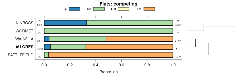
Kinross-Au Gres complex, 0 to 3 percent slopes | KinauA | 775 | 3155922 | 2ythf | mi009 | 1976 | 1:15840 |
Au Gres-Finch sands, 0 to 4 percent slopes | AuA | 638 | 241488 | 838y | mi009 | 1976 | 1:15840 |
Croswell-Au Gres sands, 0 to 3 percent slopes | CswauA | 384 | 3155897 | 2ythb | mi009 | 1976 | 1:15840 |
Au Gres association | Au | 6130 | 189117 | 6bsk | mi011 | 1964 | 1:20000 |
Au Gres sand, 0 to 2 percent slopes | ArA | 5187 | 189113 | 6bsf | mi011 | 1964 | 1:20000 |
Au Gres-Roscommon association | Aw | 2126 | 189118 | 6bsl | mi011 | 1964 | 1:20000 |
Au Gres sand, loamy substratum, 0 to 2 percent slopes | AsA | 1579 | 189115 | 6bsh | mi011 | 1964 | 1:20000 |
Au Gres-Rubicon association | Ax | 1535 | 189119 | 6bsm | mi011 | 1964 | 1:20000 |
Roscommon-Au Gres-Rubicon association, undulating | RmB | 1017 | 189248 | 6bxs | mi011 | 1964 | 1:20000 |
Au Gres sand, loamy substratum, 2 to 6 percent slopes | AsB | 437 | 189116 | 6bsj | mi011 | 1964 | 1:20000 |
Au Gres sand, 2 to 6 percent slopes | ArB | 399 | 189114 | 6bsg | mi011 | 1964 | 1:20000 |
Au Gres sand, 0 to 3 percent slopes | 17A | 3464 | 414953 | 2xxht | mi013 | 1984 | 1:20000 |
Au Gres sand, 0 to 4 percent slopes | ArA | 2265 | 190396 | 6d3t | mi029 | 1970 | 1:15840 |
Au Gres sand, loamy substratum, 0 to 4 percent slopes | AuA | 738 | 190397 | 6d3v | mi029 | 1970 | 1:15840 |
Au Gres sand, 0 to 3 percent slopes | AugaaA | 1 | 3156011 | 2ythc | mi029 | 1970 | 1:15840 |
Au Gres sand, 0 to 3 percent slopes | 41A | 14515 | 190589 | 6db1 | mi031 | 1988 | 1:15840 |
Au Gres-Roscommon complex, 1 to 4 percent slopes | 70B | 4438 | 190611 | 6dbr | mi031 | 1988 | 1:15840 |
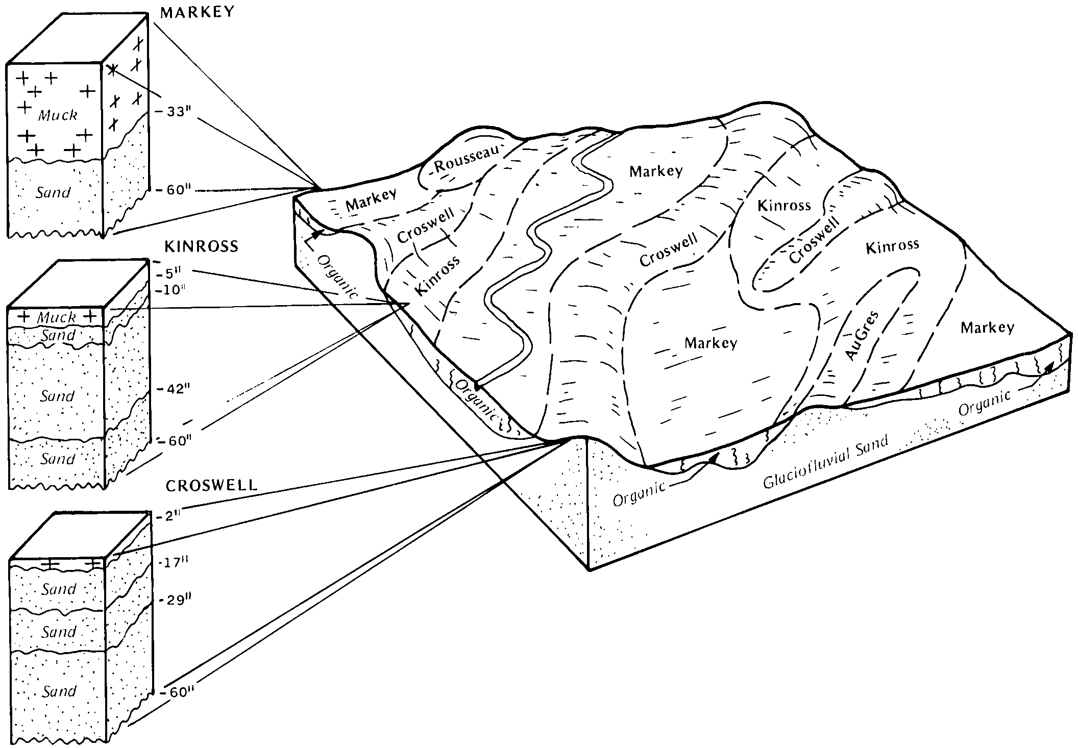
Markey-Kinross-Au Gres complex, 0 to 3 percent slopes | 94A | 19740 | 415185 | fy12 | mi033 | 1989 | 1:15840 |
Kinross-Au Gres complex, 0 to 3 percent slopes | 89A | 17735 | 415179 | fy0w | mi033 | 1989 | 1:15840 |
Croswell-Au Gres sands, 0 to 3 percent slopes | 88A | 10820 | 415178 | fy0v | mi033 | 1989 | 1:15840 |
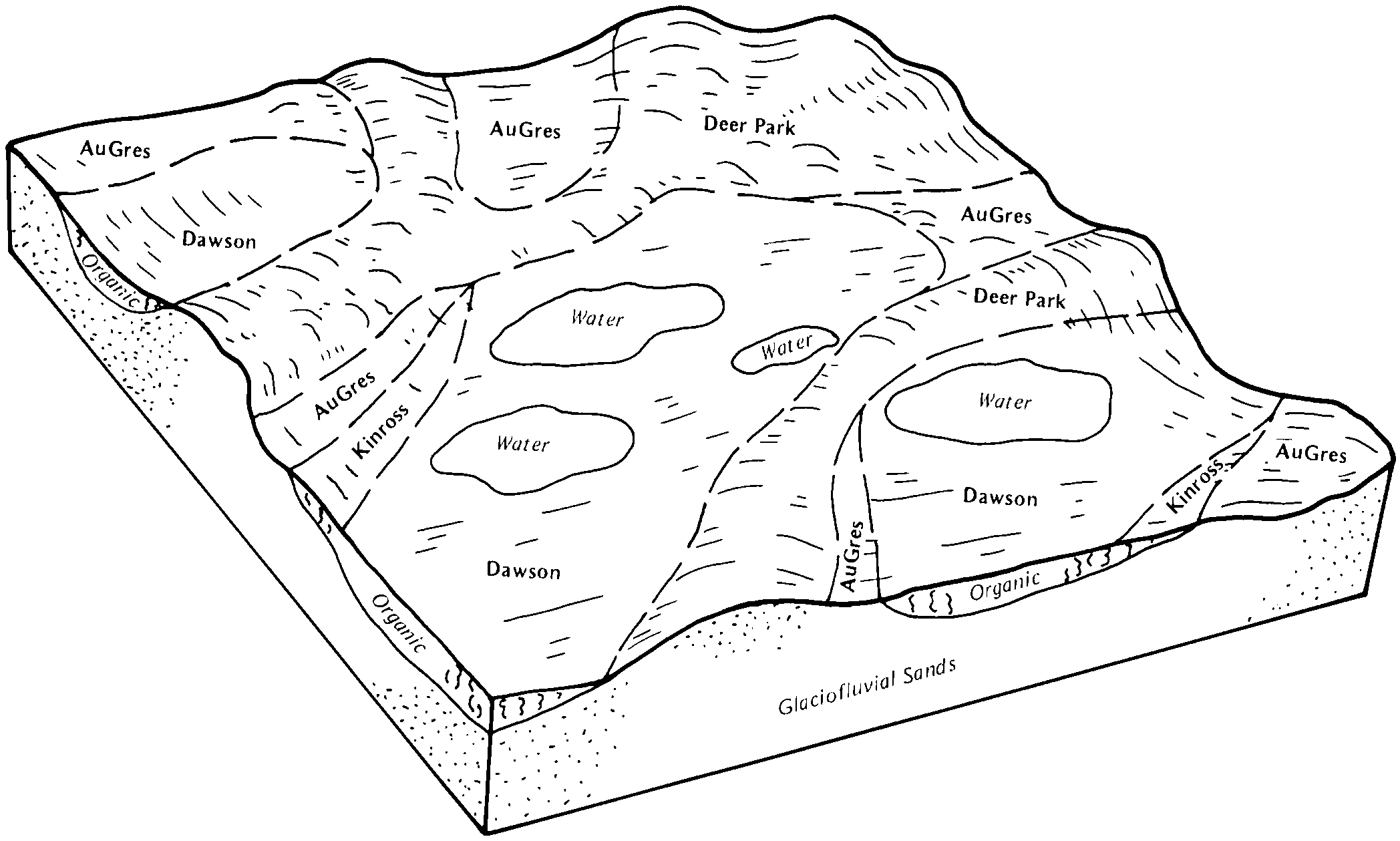
Au Gres-Dawson-Rubicon complex, 0 to 15 percent slopes | 39D | 8627 | 415146 | fxzt | mi033 | 1989 | 1:15840 |
Au Gres sand, 0 to 3 percent slopes | 21A | 8097 | 415131 | 2xxht | mi033 | 1989 | 1:15840 |
Au Gres loamy sand, 0 to 2 percent slopes | AuA | 6513 | 189609 | 6c9f | mi035 | 1977 | 1:15840 |
Croswell-Au Gres sands, 0 to 3 percent slopes | 15A | 4059 | 189659 | 6cc1 | mi039 | 1993 | 1:15840 |
Kinross-Au Gres complex, 0 to 3 percent slopes | 24A | 3543 | 189701 | 6cdd | mi039 | 1993 | 1:15840 |
Au Gres sand, 0 to 3 percent slopes | 18A | 1398 | 189662 | 6cc4 | mi039 | 1993 | 1:15840 |
Au Gres-Kinross-Croswell complex, 0 to 6 percent slopes | 50B | 984 | 189722 | 6cf2 | mi039 | 1993 | 1:15840 |
Au Gres sand, nearly level | 262A | 233 | 189702 | 6cdf | mi039 | 1993 | 1:15840 |
Au Gres sand, 0 to 3 percent slopes | AuB | 15158 | 1588015 | 2xxht | mi041 | 1969 | 1:24000 |
Au Gres sand, 0 to 6 percent slopes | ArB | 5187 | 189306 | 6bzn | mi047 | 1968 | 1:20000 |
Au Gres loamy sand, gravelly subsoil variant, 0 to 6 percent slopes | AvB | 2361 | 189308 | 6bzq | mi047 | 1968 | 1:20000 |
Au Gres loamy sand, loamy substratum, 0 to 6 percent slopes | AuB | 831 | 189307 | 6bzp | mi047 | 1968 | 1:20000 |
Croswell-Au Gres association | CT | 3905 | 189771 | 6cgn | mi051 | 1966 | 1:15840 |
Chelsea-Au Gres association | CG | 3484 | 189765 | 6cgg | mi051 | 1966 | 1:15840 |
Iosco-Au Gres-Ingalls association | IA | 3435 | 189790 | 6ch8 | mi051 | 1966 | 1:15840 |
Croswell-Au Gres-Roscommon association | CW | 3173 | 189773 | 6cgq | mi051 | 1966 | 1:15840 |
Au Gres sand, 0 to 2 percent slopes | ArA | 1981 | 189743 | 6cfr | mi051 | 1966 | 1:15840 |
Au Gres-Roscommon association | AW | 1879 | 189747 | 6cfw | mi051 | 1966 | 1:15840 |
Grayling-Croswell-Au Gres association | GU | 663 | 189786 | 6ch4 | mi051 | 1966 | 1:15840 |
Au Gres-Kinross loamy substratum association | AV | 650 | 189746 | 6cfv | mi051 | 1966 | 1:15840 |
Au Gres-Kinross association | AU | 639 | 189745 | 6cft | mi051 | 1966 | 1:15840 |
Croswell-Au Gres-Kinross association | CU | 513 | 189772 | 6cgp | mi051 | 1966 | 1:15840 |
Au Gres sand, loamy substratum, 0 to 2 percent slopes | AsA | 163 | 189744 | 6cfs | mi051 | 1966 | 1:15840 |
Au Gres-Saugatuck sands, 0 to 2 percent slopes | AsA | 845 | 189389 | 6c2b | mi055 | 1963 | 1:15840 |
Au Gres-Saugatuck sands, 2 to 6 percent slopes | AsB | 189 | 189390 | 6c2c | mi055 | 1963 | 1:15840 |
Au Gres-Roscommon complex, 0 to 3 percent slopes | 100A | 6695 | 416033 | fyxf | mi061 | 1989 | 1:20000 |
Halfaday-Au Gres sands, 0 to 3 percent slopes | 134A | 6094 | 416073 | fyyq | mi061 | 1989 | 1:20000 |
Croswell-Au Gres sands, 0 to 3 percent slopes | 75A | 2434 | 416158 | fz1g | mi061 | 1989 | 1:20000 |
Au Gres sand, 0 to 3 percent slopes | 18A | 1994 | 416106 | 2xxht | mi061 | 1989 | 1:20000 |
Au Gres-Kinross complex, 0 to 3 percent slopes | 76A | 1268 | 416159 | fz1h | mi061 | 1989 | 1:20000 |
Kellogg, sandy substratum-Au Gres-Kinross complex, 0 to 4 percent slopes | 8232B | 801 | 2485001 | 2pdvb | mi061 | 1989 | 1:20000 |
Au Gres sand | As | 242 | 187868 | 69h8 | mi067 | 1965 | 1:15840 |
Au Gres sand, 0 to 3 percent slopes | 18A | 8083 | 191724 | 6fhn | mi069 | 1995 | 1:15840 |
Au Gres-Deford complex, 0 to 3 percent slopes | 368A | 7726 | 191831 | 6fm3 | mi069 | 1995 | 1:15840 |
Finch-Deford-Au Gres complex, 0 to 3 percent slopes | 409A | 1830 | 191855 | 6fmw | mi069 | 1995 | 1:15840 |
Au Gres sand, nearly level | 262A | 1632 | 191802 | 6fl5 | mi069 | 1995 | 1:15840 |
Croswell-Au Gres sands, 0 to 3 percent slopes | 15A | 403 | 191717 | 6fhf | mi069 | 1995 | 1:15840 |
Tawas-Au Gres complex, 0 to 4 percent slopes | 12B | 203 | 191711 | 6fh7 | mi069 | 1995 | 1:15840 |
Au Gres sand, 0 to 3 percent slopes | 74A | 888 | 416015 | 2xxht | mi071 | 1992 | 1:20000 |
Au Gres sand, 0 to 3 percent slopes | 18A | 6471 | 190633 | 6dcg | mi079 | 1998 | 1:12000 |
Au Gres-Roscommon complex, 0 to 3 percent slopes | 174A | 3592 | 190710 | 6dfy | mi079 | 1998 | 1:12000 |
Croswell-Au Gres sands, 0 to 3 percent slopes | 15A | 2940 | 190630 | 6dcc | mi079 | 1998 | 1:12000 |
Kinross-Au Gres complex, 0 to 3 percent slopes | 24A | 1533 | 190641 | 6dcq | mi079 | 1998 | 1:12000 |
Au Gres-Kinross-Croswell complex, 0 to 6 percent slopes | 50B | 919 | 190662 | 6ddd | mi079 | 1998 | 1:12000 |
Au Gres-Deford complex, 0 to 3 percent slopes | AugdeA | 4 | 3187038 | 2ytj7 | mi079 | 1998 | 1:12000 |
Au Gres-Kalkaska sands, 0 to 4 percent slopes | AuA | 3841 | 190780 | 6dj6 | mi089 | 1967 | 1:20000 |
Kinross-Au Gres complex, 0 to 3 percent slopes | 60A | 4881 | 627505 | p1z3 | mi095 | 2004 | 1:24000 |
Au Gres-Dawson-Rubicon complex, 0 to 15 percent slopes | 110D | 2534 | 631300 | p5xj | mi095 | 2004 | 1:24000 |
Croswell-Au Gres sands, 0 to 6 percent slopes | 88B | 717 | 653852 | pyd0 | mi095 | 2004 | 1:24000 |
Au Gres-Dawson-Rubicon complex, 0 to 35 percent slopes | 110E | 287 | 631301 | p5xk | mi095 | 2004 | 1:24000 |
Au Gres sand, 0 to 3 percent slopes | 17A | 8102 | 395135 | 2xxht | mi103 | 1999 | 1:24000 |
Au Gres-Deford complex, 0 to 3 percent slopes | 203A | 1955 | 395160 | f863 | mi103 | 1999 | 1:24000 |
Au Gres loamy sand, 0 to 3 percent slopes | 16A | 11781 | 192420 | 6g73 | mi113 | 1983 | 1:15840 |
Deford-Au Gres-Croswell complex, 0 to 6 percent slopes | 352B | 5519 | 192248 | 6g1k | mi119 | 1997 | 1:12000 |
Au Gres sand, 0 to 3 percent slopes | 18A | 2047 | 192206 | 6g06 | mi119 | 1997 | 1:12000 |
Kinross-Au Gres complex, 0 to 3 percent slopes | 24A | 312 | 192225 | 6g0t | mi119 | 1997 | 1:12000 |
Roscommon and Au Gres sands | Ra | 27019 | 187373 | 68z9 | mi121 | 1966 | 1:15840 |
Au Gres sand, 0 to 3 percent slopes | 13A | 5537 | 189875 | 6cl0 | mi129 | 1987 | 1:15840 |
Croswell-Au Gres-Tawas complex, 0 to 18 percent slopes | 120D | 2251 | 1456543 | 1kwn8 | mi131 | 2007 | 1:24000 |
Au Gres-Deford complex, 0 to 3 percent slopes | 19A | 1062 | 1456400 | 1kwhn | mi131 | 2007 | 1:24000 |
Kellogg, sandy substratum-Au Gres-Kinross complex, 0 to 4 percent slopes | 8232B | 674 | 1674869 | 1t6v1 | mi131 | 2007 | 1:24000 |
Au Gres sand, 0 to 3 percent slopes | 18A | 160 | 1456399 | 2xxht | mi131 | 2007 | 1:24000 |
Au Gres sand, 0 to 6 percent slopes | ArB | 3641 | 189980 | 6cpd | mi133 | 1966 | 1:15840 |
Au Gres sand, loamy substratum, 0 to 6 percent slopes | AuB | 630 | 189981 | 6cpf | mi133 | 1966 | 1:15840 |
Deford-Au Gres-Croswell complex, 0 to 6 percent slopes | 352B | 7632 | 241413 | 836j | mi135 | 2003 | 1:12000 |
Au Gres sand, nearly level | 262A | 2476 | 241407 | 836b | mi135 | 2003 | 1:12000 |
Au Gres-Deford complex, 0 to 3 percent slopes | 368A | 2125 | 209041 | 70j8 | mi135 | 2003 | 1:12000 |
Croswell-Au Gres sands, 0 to 3 percent slopes | 15A | 1429 | 241378 | 835d | mi135 | 2003 | 1:12000 |
Au Gres sand, 0 to 3 percent slopes | 18A | 546 | 241381 | 835h | mi135 | 2003 | 1:12000 |
Haplosaprists, euic-Au Gres complex, nearly level | 252A | 219 | 241463 | 8384 | mi135 | 2003 | 1:12000 |
Kinross-Au Gres complex, 0 to 3 percent slopes | 24A | 114 | 241388 | 835q | mi135 | 2003 | 1:12000 |
Au Gres-Kinross-Croswell complex, 0 to 6 percent slopes | 50B | 5 | 241390 | 835s | mi135 | 2003 | 1:12000 |
Croswell-Au Gres sands, 0 to 3 percent slopes | 15A | 1776 | 191452 | 6f6w | mi137 | 1998 | 1:12000 |
Au Gres sand, 0 to 3 percent slopes | 18A | 814 | 191456 | 6f70 | mi137 | 1998 | 1:12000 |
Au Gres-Deford complex, 0 to 3 percent slopes | 368A | 650 | 191485 | 6f7y | mi137 | 1998 | 1:12000 |
Deford-Au Gres-Croswell complex, 0 to 6 percent slopes | 352B | 591 | 191483 | 6f7w | mi137 | 1998 | 1:12000 |
Kinross-Au Gres complex, 0 to 3 percent slopes | 24A | 419 | 191462 | 6f76 | mi137 | 1998 | 1:12000 |
Au Gres-Kinross-Croswell complex, 0 to 6 percent slopes | 50B | 190 | 191504 | 6f8k | mi137 | 1998 | 1:12000 |
Au Gres loamy sand, 0 to 6 percent slopes | AmB | 5504 | 192632 | 6gfy | mi139 | 1967 | 1:15840 |
Au Gres loamy sand, loamy substratum, 0 to 6 percent slopes | ArB | 1945 | 192633 | 6gfz | mi139 | 1967 | 1:15840 |
Au Gres sand, 0 to 3 percent slopes | 25A | 5726 | 190875 | 6dm8 | mi141 | 1989 | 1:15840 |
Au Gres-Roscommon complex, 0 to 3 percent slopes | 70A | 5216 | 190935 | 6dp6 | mi141 | 1989 | 1:15840 |
Au Gres sand, loamy substratum, 0 to 2 percent slopes | 44A | 3979 | 190896 | 6dmy | mi141 | 1989 | 1:15840 |
Deer Park-Croswell-Au Gres complex, 0 to 12 percent slopes | 56C | 3467 | 190914 | 6dnj | mi141 | 1989 | 1:15840 |
Au Gres-Kinross-Croswell complex, 0 to 6 percent slopes | 50B | 14740 | 191003 | 6drd | mi143 | 1999 | 1:12000 |
Croswell-Au Gres sands, 0 to 3 percent slopes | 15A | 9905 | 190994 | 6dr3 | mi143 | 1999 | 1:12000 |
Augres-Deford complex, 0 to 3 percent slopes | 368A | 5132 | 190985 | 6dqt | mi143 | 1999 | 1:12000 |
Au Gres sand, 0 to 3 percent slopes | 18A | 4899 | 190982 | 6dqq | mi143 | 1999 | 1:12000 |
Kinross-Au Gres complex, 0 to 3 percent slopes | 24A | 4118 | 191000 | 6dr9 | mi143 | 1999 | 1:12000 |
Deford-Rubicon-Au Gres complex, 0 to 15 percent slopes | 540D | 14779 | 1612304 | 1r3qt | mi153 | 2007 | 1:24000 |
Kinross-Au Gres-Rubicon complex, 0 to 15 percent slopes | 541D | 11167 | 1650342 | 1sd9v | mi153 | 2007 | 1:24000 |
Au Gres-Deford complex, 0 to 3 percent slopes | 19A | 6506 | 1456938 | 1kx20 | mi153 | 2007 | 1:24000 |
Au Gres sand, 0 to 3 percent slopes | 17A | 1104 | 1456937 | 2xxht | mi153 | 2007 | 1:24000 |
Au Gres-Finch sands, 0 to 4 percent slopes | 10A | 11713 | 190734 | 6dgq | mi600 | 1983 | 1:15840 |
Au Gres-Deford-Croswell complex, 0 to 6 percent slopes | 126B | 3486 | 800765 | vw84 | mi605 | 2004 | 1:24000 |
Croswell-Au Gres complex, 0 to 3 percent slopes | 125A | 1320 | 800767 | vw86 | mi605 | 2004 | 1:24000 |
Au Gres-Kinross complex, 0 to 3 percent slopes | 127A | 1008 | 435360 | gm0w | mi605 | 2004 | 1:24000 |
Au Gres-Scarboro-Croghan association | Ada | 12899 | 2677430 | bmbr | ny033 | 2018 | 1:24000 |
Walpole, neutral variant, and Au Gres loamy sands, 0 to 6 percent slopes | Wka | 4936 | 2677559 | bmgh | ny033 | 2018 | 1:24000 |
Walpole and Au Gres loamy sands, 0 to 6 percent slopes | Wha | 1627 | 2677468 | bmgg | ny033 | 2018 | 1:24000 |
Au Gres fine sandy loam | Au | 2040 | 281664 | 9g2y | vt007 | 1969 | 1:15840 |
Au Gres loamy fine sand, 0 to 6 percent slopes | AuA | 3193 | 281768 | 9g69 | vt011 | 1976 | 1:20000 |
Au Gres loamy sand | Au | 1818 | 422920 | g62l | wi001 | 1978 | 1:20000 |
Au Gres loamy sand, 0 to 3 percent slopes | 3276A | 2220 | 1444535 | 2xxhr | wi003 | 2006 | 1:12000 |
Au Gres loamy sand, 0 to 3 percent slopes | 3276A | 1124 | 1383557 | 2xxhr | wi007 | 2005 | 1:12000 |
Au Gres-Newson complex, 0 to 3 percent slopes | AnA | 804 | 431839 | ghc9 | wi019 | 1994 | 1:20000 |
Au Gres loamy sand, 0 to 3 percent slopes | 3276A | 2885 | 781169 | 2xxhr | wi031 | 2005 | 1:12000 |
Au Gres sand, 0 to 3 percent slopes | 3676A | 402 | 781431 | 2xxht | wi031 | 2005 | 1:12000 |
Au Gres loamy sand | Au | 3037 | 421744 | g4vn | wi035 | 1974 | 1:15840 |
Au Gres loamy sand, 0 to 3 percent slopes | Au | 659 | 429992 | 2xxhr | wi037 | 1995 | 1:12000 |
Au Gres loamy sand, 0 to 3 percent slopes | Au | 1048 | 429832 | 2xxhr | wi041 | 1995 | 1:12000 |
Au Gres loamy sand, 0 to 3 percent slopes | 3276A | 5150 | 782037 | 2xxhr | wi051 | 2006 | 1:12000 |
Kinross-Au Gres-Markey complex, 0 to 3 percent slopes | 455A | 3527 | 1702181 | 1v482 | wi051 | 2006 | 1:12000 |
Au Gres loamy sand, 0 to 3 percent slopes | As | 1547 | 421046 | 2xxhr | wi067 | 1983 | 1:20000 |
Au Gres loamy sand, 0 to 3 percent slopes | AuA | 3026 | 431608 | 2xxhr | wi069 | 1993 | 1:20000 |
Au Gres loamy sand, 0 to 3 percent slopes | AuA | 26157 | 422376 | 2xxhr | wi075 | 1987 | 1:20000 |
Au Gres loamy sand, 0 to 3 percent slopes | AuA | 1648 | 395780 | 2xxhr | wi078 | 1998 | 1:12000 |
Au Gres loamy sand, 0 to 3 percent slopes | Au | 14535 | 421078 | 2xxhr | wi085 | 1988 | 1:20000 |
Au Gres loamy sand, 0 to 3 percent slopes | 3276A | 2746 | 1482736 | 2xxhr | wi099 | 2006 | 1:12000 |
Au Gres loamy sand, 0 to 3 percent slopes | 3276A | 14 | 1481490 | 2xxhr | wi107 | 2006 | 1:12000 |
Au Gres loamy sand, 0 to 3 percent slopes | 3276A | 1349 | 1669954 | 2xxhr | wi113 | 2006 | 1:12000 |
Au Gres loamy sand, 0 to 3 percent slopes | AuA | 6615 | 422652 | 2xxhr | wi115 | 1981 | 1:15840 |
Au Gres variant loamy fine sand, 0 to 3 percent slopes | AxA | 1457 | 422653 | g5sz | wi115 | 1981 | 1:15840 |
Au Gres loamy sand, 0 to 3 percent slopes | Au | 6902 | 421228 | 2xxhr | wi125 | 1985 | 1:20000 |
Au Gres loamy sand, 0 to 3 percent slopes | 3276A | 254 | 723602 | 2xxhr | wi129 | 2002 | 1:12000 |

